Drone Detection Radar

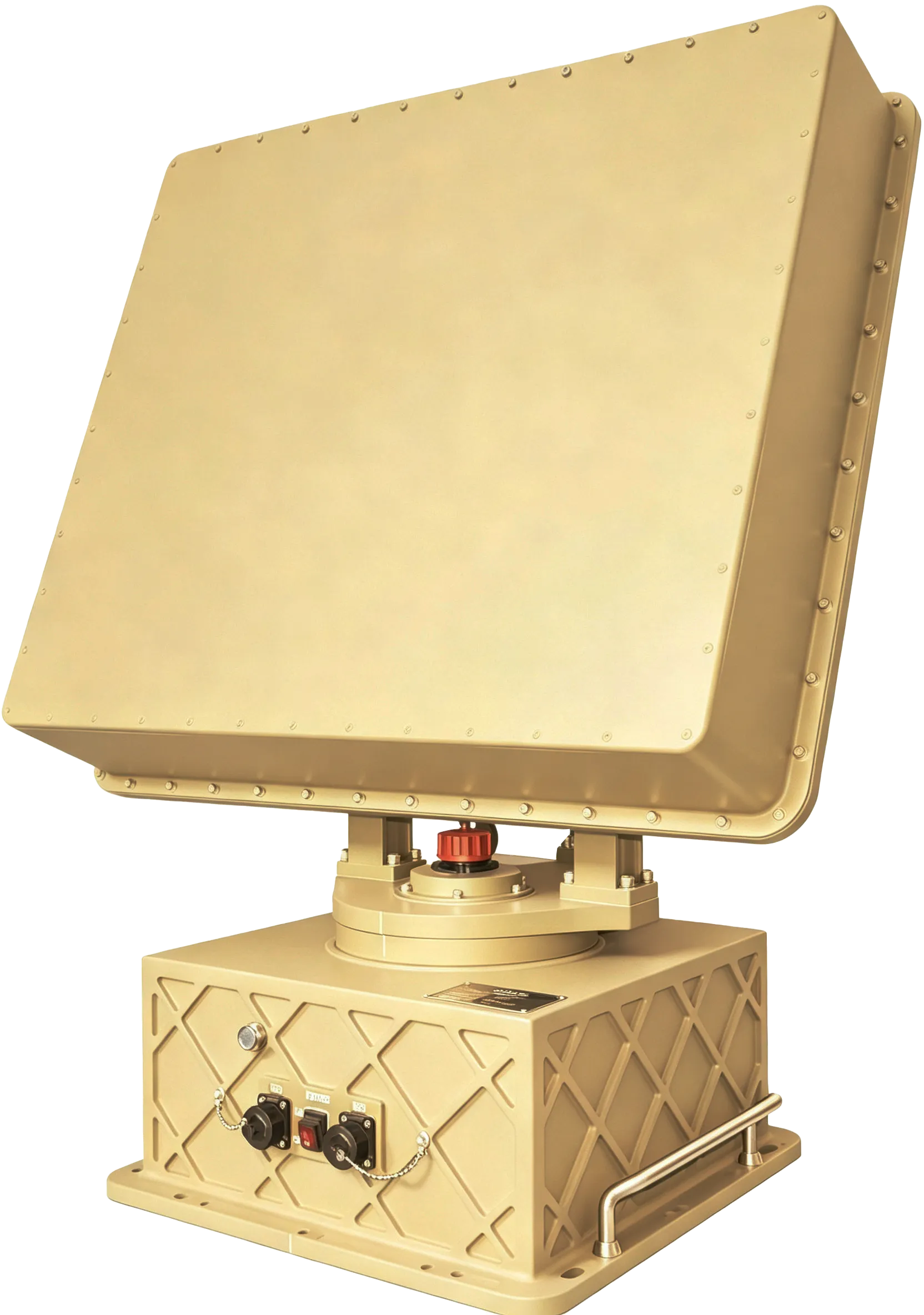
Affordable and reliable FMCW radar optimized for drone detection and tracking. 360° coverage with AI-powered target clustering — 24/7 protection in all weather conditions.

Counter-UAV Solutions

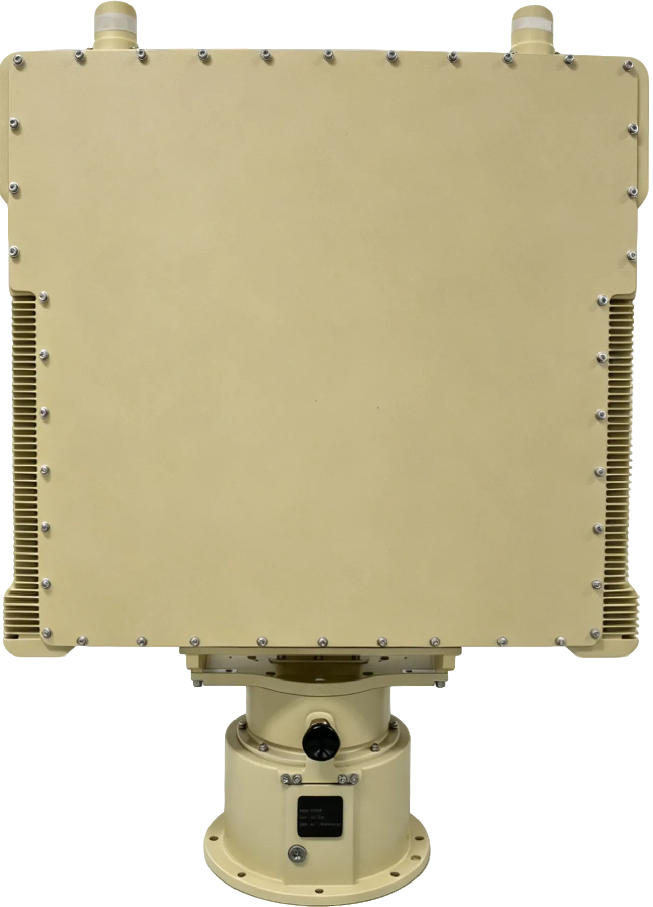
UD04K & UD06K

An affordable and reliable FMCW radar optimized for drone detection and tracking, designed to better safeguard your airspace.

By adopting advanced FMCW (Frequency Modulated Continuous Wave) and DBF (Digital Beam Forming) technologies, it offers 360° coverage in 4D with a wide elevation beam (0~40°).

KEY CAPABILITIES
  • 4D tracking of UAV within range up to 20,000 ft
  • Simultaneous tracking of 128+ targets
  • AI-empowered algorithm for target clustering & lower false alarms
  • FMCW technology for low probability of interception
  • Integrated internal GPS for precise positioning
  • Reliable protection 24/7 in all weather conditions

360° Full Coverage

Complete 360° azimuth coverage with wide elevation beam (0~40°) — no blind zones for comprehensive airspace protection.

4D Detection & Tracking

Simultaneous measurement of range, azimuth, elevation, and velocity — 4D tracking for up to 128 targets simultaneously.

Up to 20,000 ft Range

UD04K detects drones up to 15,000 ft; UD06K extends to 20,000 ft — sufficient for most critical infrastructure protection scenarios.

Military-Grade Build

IP66-rated ruggedized construction with industrial-certified durability. Built to withstand extreme environments and deliver reliable performance in the harshest conditions.

24/7 Protection

All-Weather Reliability

The radar is immune to many environmental conditions, such as light, rain, dust, fog, and smoke. Built with industry-certified rugged design, it ensures stable performance and continuous protection even in the harshest environments.
Rain
Fog
Dust
Night
UD03K Drone Detection Radar

UD03K

The UD03K is a 24 GHz FMCW radar delivering 360° 4D detection and tracking — range, azimuth, elevation, and velocity — purpose-built for low-altitude, slow-moving UAV threats. Massive MIMO combined with Digital Beamforming (DBF) and AI-powered clustering ensures reliable target acquisition with an exceptionally low false-alarm rate, even in cluttered urban environments.

Tracking up to 100+ targets simultaneously across a full 360° azimuth sweep, the UD03K provides complete airspace awareness for critical infrastructure, public venues, and perimeter security applications.

360°
Full azimuth coverage
10,000 ft
Small drone detection
100+
Simultaneous tracks
360° 4D Active Detection
Mechanical rotation sweeps full 360° while DBF tilts the elevation beam 0–30° — delivering true 4D data — range, azimuth, elevation, and velocity — for every tracked target.
High-Precision Target Resolution
AI-empowered clustering resolves individual targets even in dense environments, with ≤1° azimuth accuracy and ≤2° elevation accuracy.
Continuous Smooth Tracking
100+ simultaneous tracks with smooth trajectory association. User-selectable 10 or 20 RPM scan rate adapts to airspace density and threat tempo.
Core Technology

AI · FMCW · Easy Deploy

Three pillars of innovation — intelligent AI-powered classification, reliable FMCW radar technology, and seamless deployment integration.

Target Clustering

AI-facilitated algorithm distinguishes genuine drone threats from birds, debris and other flying objects — dramatically reducing false alarm rates.

Environmental Awareness

Intelligent adaptation to surrounding environment minimizes false alerts caused by wind, vegetation and small animals.

EO Camera Cueing

Radar data guides EO/IR cameras for visual confirmation of threats, enabling rapid identification and faster response.

Low Probability of Intercept

FMCW radar signal is difficult to detect by adversaries — critical for military and security applications.

Massive MIMO + DBF

Large-scale antenna array with digital beam forming delivers high angular resolution and precise target localization.

24GHz K-Band

Optimized frequency band for drone detection — balanced between range, resolution, and antenna size.

Modular Design

Plug-and-play modular architecture for fast installation and simple field maintenance. Deploy as standalone or integrated with existing security systems.

Open Architecture

UDP/TCP communication protocol with Gigabit Ethernet interface — seamless integration into your current system.

User-Friendly Interface

Intuitive console with real-time map display, alarm management and device configuration. No specialized training required.

How It Works

Radar Detection in Action

Our mechanical scanning radar sweeps 360° while its DBF elevation beam scans the sky — detecting, tracking, and classifying aerial threats in real time.

Range: 9,842 ft Speed: 45 mph Altitude: 1,500 ft 360° SURVEILLANCE — REAL-TIME DETECTION & TRACKING
Technical Specifications

UD03K / UD04K / UD06K

Three models covering short, medium, and long-range drone detection — powered by AI intelligence, FMCW radar, and easy integration.

Model UD03KUD03K
Download Datasheet
UD04KUD04K
Download Datasheet
UD06KUD06K
Download Datasheet
Radar & Performance
Radar TypeFrequency Modulated Continuous Wave (FMCW)
Frequency BandK Band (24 GHz)
Scan Type Mechanical scanning in azimuth DBF in elevation; Mechanical scanning in azimuth DBF in elevation; Mechanical scanning in azimuth
Scan Speed10 RPM (60°/s) or 20 RPM (120°/s) — user selectable
Detection & Accuracy (RCS=0.01m²)
Max Detection Range 10,000 ft 15,000 ft 20,000 ft
Range Resolution± 12 ft
Range Accuracy ≤ 33 ft 6 ft 6 ft
Max Simultaneous Tracking 100 128 128
Maximum Target Velocity Up to 67 mph Up to 134 mph Up to 134 mph
Azimuth Coverage0 ~ 360°
Elevation Coverage 0 ~ 30° 0 ~ 40° 0 ~ 40°
Angular Accuracy ≤ 1° (Az), ≤ 2° (El) 0.4° (Azimuth & Elevation) 0.4° (Azimuth & Elevation)
Angular Resolution N/A 1.5° (Azimuth & Elevation) 1.5° (Azimuth & Elevation)
Power
Power SupplyAC 100 ~ 240V / DC 24V
Power Consumption ≤ 160 W ≤ 350 W ≤ 550 W
Network
Communication ProtocolUDP / TCP
Communication Interface RJ45 Gigabit Ethernet Gigabit Ethernet
Environment
IP Rating IP65 IP66 IP66
Working Temperature-40 ~ 140°F (storage and operation)
Dimension & Weight
Dimension 29.1 * 23.6 * 23.6 in 21.4 * 8.8 * 30.4 in 21.4 * 8.8 * 30.4 in
Weight66 lb
System Overview

End-to-End Defense Solution

Integrated three-layer architecture — from detection to analysis to countermeasures — all coordinated through a single intelligent platform.

Detection

Multi-sensor fusion for comprehensive airspace awareness

RADAR
Drone Detection Radar
RF
Drone RF Detector
EO/IR
EO Drone Tracking Camera

Analysis

AI-powered intelligent processing and threat assessment

AI
Multi-sensor Fusion + AI
ALGO
Intelligent Algorithm
REC
AI Recognition & Classification

Countermeasure

Rapid response and threat neutralization

JAM
Drone RF Jammer
SPOOF
Navigation Spoofer
EVAL
Effect Evaluation
Smart Control Platform

Professional Drone Defense Console

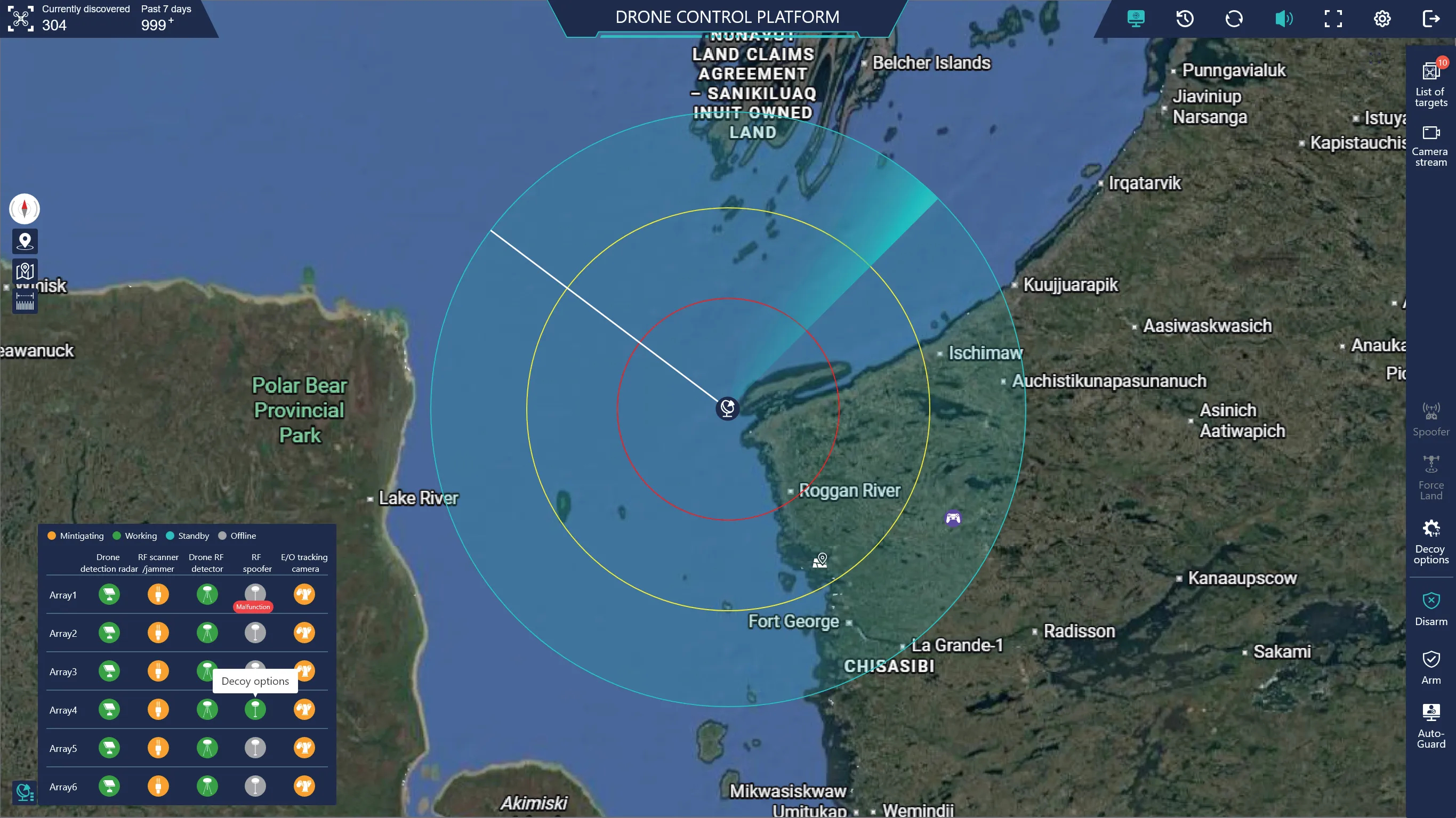
User-friendly interface for comprehensive drone detection, tracking, identification and mitigation — all on a single map.

Real-time Console

Real-time Console

Instant Threat Visibility

Receive instant and reliable real-time information of any potential threat with inputs from all sensors displayed on a single map. Smart deployment and auto-guard features enable instant confirmation and reaction.

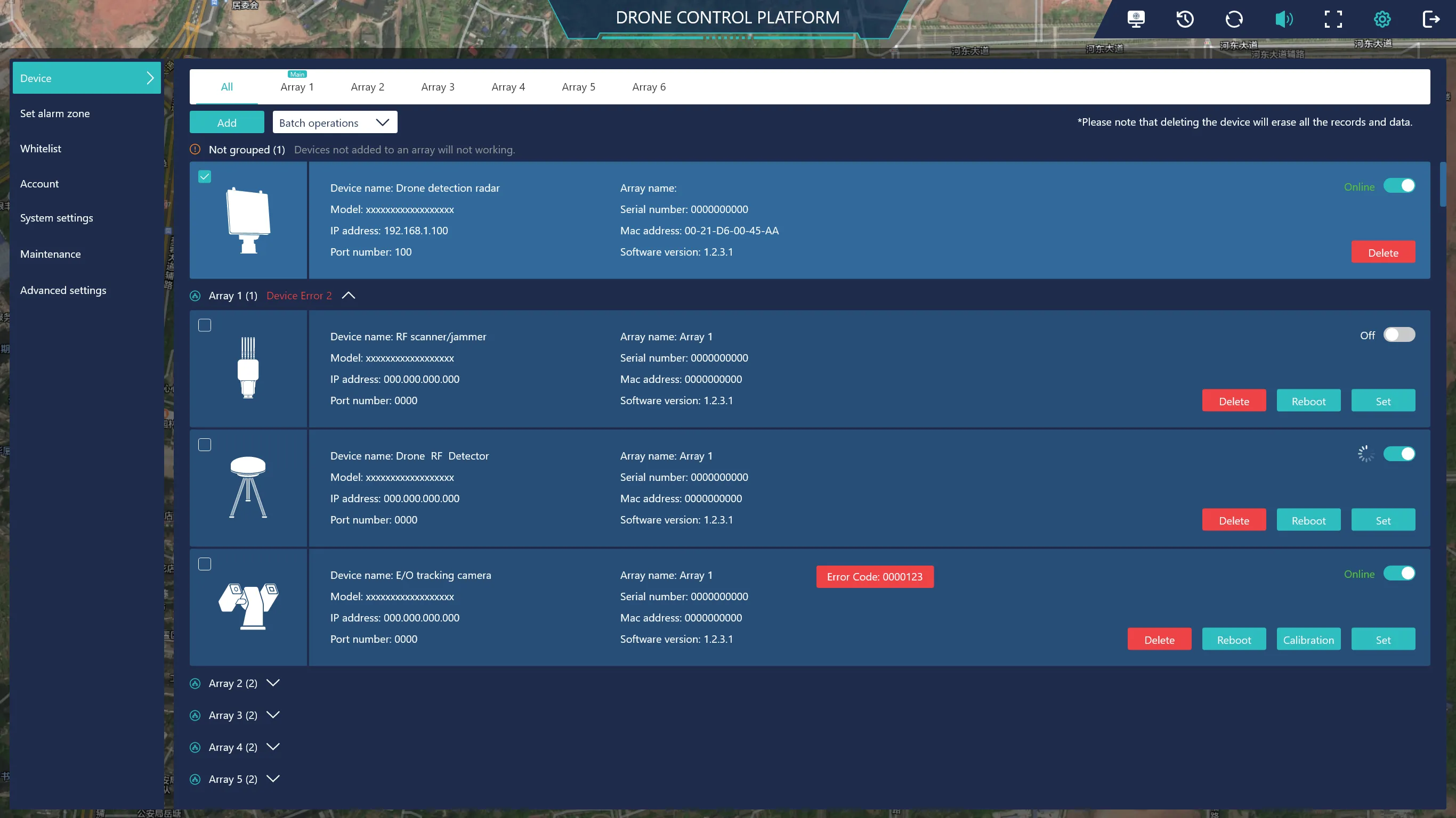
Device Management

Device Management

Multi-sensor Control

Add and manage all sensors for system configuration or day-to-day maintenance. Support for multiple sensors deployed in up to six different locations — all from one central console.

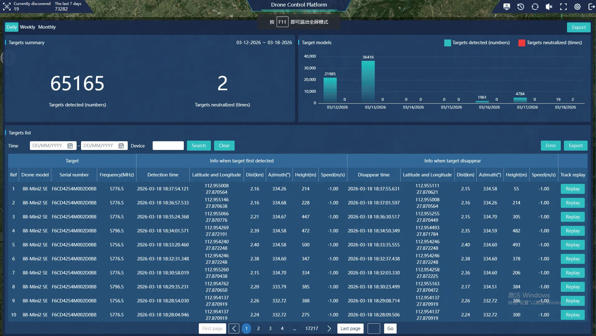
History & Replay

History & Replay

Incident Analysis

Thorough summary of every incident, threat, and action detected or performed. Generate flight track of any threat in interest for detailed analysis and evidence collection.

KEY PLATFORM FEATURES
Multi-Location
Up to 6 deployment zones
Auto-Guard
24/7 unattended operation
Smart Fusion
Multi-sensor integration
Reports
Custom incident reports
User-Friendly
Intuitive interface

Ready to secure your airspace?

Our team will walk you through the full system capabilities, integration options and pricing.

Request Quote & Demo →

INQ